Mozambique has 10 provinces, but the city of Maputo is also considered as a province so bringing the number of provinces to 11.
Mozambique is divided by the mighty Zambezi River,between north and south, which is and has been a formidable barrier for people to cross.
The Zambezi was a major obstacle for the Nguni people migrating southwards, with their herds of cattle and stock.
It still is today and crossing the Zambezi is a major consideration for any traveler wanting to explore the northern four provinces from the south. The Zambezi does not have easy access over the river.
CABO DELGADO PROVINCE
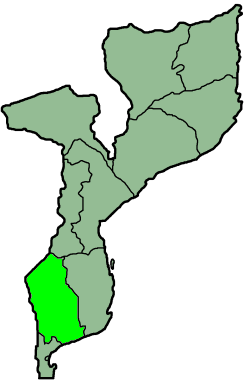
GAZA PROVINCE
INHAMBANE
MANICA PROVINCE
NAMPULA PROVINCE
MAPUTO CITY
MAPUTO PROVINCE
NIASSA PROVINCE
SOFALA PROVINCE
TETE
ZAMBEZIA PROVINCE |
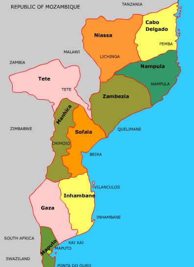 |
Basically there are four provinces north of the Zambezi. Tete does have a portion of it's province on the northern side of the Zambezi but in effect the four northern provinces are Zambezia, Nampula, Cabo Delgado and Niassa.
This is rugged and beautiful country.
To start with theZambezi River is an awe inspiring natural phenomenon, from the mighty impressive Cahora Bassa Dam and hydro-electricity project, down to the Delta and the swamps and Marromeu Reserve, the Zambezi provides a feat of nature that holds a person seeing this spectacle for the first time spell bound.
CABO DELGADO PROVINCE
Cabo Delgado is the most northerly province of Mozambique and is 77,867 square kilometres in extent Tanzania is across the Rovuma River to the north, to the east is the Indian Ocean, to the south is Nampula province and to the west is Niassa province.
The main products of Cabo del Gabo are marble,clay, graphite and hardwood timber.
The Rovuma River poses a formidable barrier and there is only one ferry that can ferry vehicles across it. All other crossings are pedestrian and done by dugouts.
The Capital of Cabo Delgado is Pemba (It used to be named Porto Amelia), which is situated at the mouth of a large bay of the same name. Pemba Bay is considered to be the worlds largest inland bay and it is 375 sq kms in size with beautiful blue water that is uniformly 24 metres deep. There are stories of German U Boats using Pemba Bay to stock up with supples during World War II. The mouth of Pemba Bay is only 2 kms wide.
There has never been much trading activity at Pemba, as this was was concentrated more to the south as well as the off-shore islands of Mozambique, with the result that there is not much industry at Pemba.
This has proved beneficial as the natural beauty has been kept and the magnificent beaches are not polluted.
The best known beaches are:-
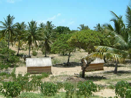
Praia do Wimbe, which has dazzling white sands fringed by palm trees and sparkling blue water.
Praia do Farol which is south of Wimbe and close to the Lighthouse (farol).
The old town of Pemba is also interesting with it's traditional markets (See the Pemba Querimba home page for more information)
Mocimboa da Praia is the closest large town to the Tanzanian border and with it's Palm trees lining the beach is also well worth a visit.
Cabo Delgado is
the home of the Makonde people, who live mostly on the Mueda plateau. The other ethnic tribe is the Makua.
The Makonde are known to be fearless and they tattoo their bodies and file their teeth. Their initiation rites are faithfully followed and Mapico masks are used during the Mapico dance which is the most important dance of the initiation ceremony.
They are also well known for their ivory and wood carvings.
At the inland town of Mueda, which is the administrative capital of the Makonde people, there is
a memorial to the Mueda Massacre. In 1964 the Makonde people rebelled against the confiscation of their land by the Portuguese.
The Makonde elders and members of the tribe attended a meeting with the Portuguese Governor.
There are conflicting reports, but discussions became heated and a riot ensued. The Portuguese soldiers opened fire with machine guns and hundreds of people were killed.
The outrage over this incident was the start of major internal resistance to Portuguese rule and led to the begining of Russian involvment in Mozambique.
|
http://en.wikipedia.org/wiki/Gaza_Province
Gaza is a province of Mozambique. It has an area of 75,709 km² and a population of 1,333,106 (2006).
Xai-Xai is the capital of the province. Inhambane Province is to the east, Manica Province to the north, Maputo Province to the south, South Africa to the west, and Zimbabwe to the northwest.
Most of the district lies in the basin of the Limpopo River, which runs from northwest to southeast through the district, emptying into the Indian Ocean near Xai-Xai.
The province, including the towns of Xai-Xai and Chokwe, was greatly affected by the 2000 Mozambique flood. |
|
| |
The Changane River, a tributary of the Limpopo, forms part of the province's eastern boundary.
The Rio dos Elefantes (Olifants River) flows into the district from the east to empty into the Limpopo.
The Save River forms the northern boundary of the district.
The Limpopo railway, which connects Zimbabwe and Botswana to the port of Maputo, runs through the province, entering Zimbabwe at the border town of Chicualacuala.
Limpopo National Park lies within the province, bounded by the Elefantes and Limpopo rivers and the South African border.
Banhine National Park lies in the east-central portion of the province.
The Great Limpopo Transfrontier Park and its associated conservation area, which is in the process of being formed, will cover the northern part of the province, including both national parks, and extend into adjacent parts of Mozambique, South Africa, and Zimbabwe |
 |
Gaza is divided into the districts of:
-
Bilene Macia District
-
Chibuto District
-
Chicualacuala District
-
Chigubo District
-
Chókwè District
-
Guijá District
-
Mabalane District
-
Manjacaze District
-
Massagena District
-
Massingir District
- Xai-Xai District
|
|
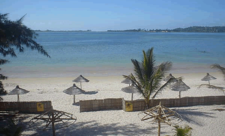
INHAMBANE PROVINCE
en.wikipedia.org/wiki/Inhambane_Province
Inhambane is a province of Mozambique located on the coast in the southern part of the country.
It has an area of 68,615 km²
The provincial capital is also called Inhambane.
The climate is tropical throughout, more humid along the coast and dryer inland. The coast has a number of mangrove swamps.
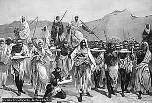
The town of Inhambane existed in the 10th century, and was the southernmost port used by Arabs for slave trading.
The region was visited by Vasco da Gama in 1498, who claimed Inhambane Bay for Portugal. The Portuguese established a trading post at Inhambane in 1534.
The province is the second largest grower of cashews (after Nampula), and also produces coconut and citrus fruit (inspiring Mozambique's most famous poet Craveirinha to write of "The Tasty Tangerines of Inhambane").
The long coastline supports much fishing. The Inhambane Bay area is of some interest for tourism, with a number of beaches, and one of the last remaining populations of dugong in Mozambique. |
 |
Districts of Inhambane Province
- Funhalouro District
- Govuro District
- Homoine District
- Jangamo District
- Inharrime District
- Inhassoro District
- Mabote District
- Massinga District
- Morrumbene District
- Panda District
- Vilankulo District
- Zavala District
|
Cities of Inhambane Province
- Inhambane provincial capital
- Maxixe largest population, and the province's economic capital
Inhambane is famous for its music, in particular the timbila (xylophone ensemble) of the Chopi ethnic group. |
MANICA PROVINCE
en.wikipedia.org/wiki/Manica_Province
Manica has an area of 61,661 km² and a population of 1,359,923 (2006)
Chimoio is the capital of the province.
MAPUTO CITY
en.wikipedia.org/wiki/Maputo
Maputo is located on the west side of Maputo Bay, near the Estuário do Espírito Santo where the rivers Tembe, Umbeluzi, Matola and Infulene drain.
The bay is 95 kilometers long and 30 kilometers wide. At the extreme east of the city and bay is the island of Inhaca.The total area covered by the municipality of Maputo is 346 km² and borders the city of Matola northeast and east, the districts of Marracuene to the north; Boane in the east and Matutuíne at the south all of which are part of Maputo Province.
The city is 120 kilometers from the South African border at Ressano Garcia and 80 kilometers from the border with Swaziland near the town of Namaacha.
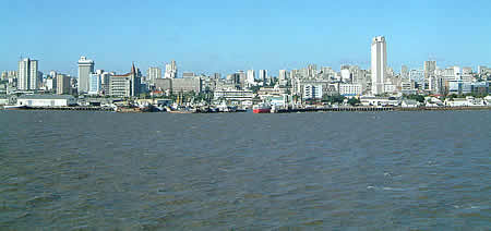
Maputo, known as Lourenço Marques before independence, is the capital and largest city of Mozambique.
|
 |
It is known as the City of Acacias in reference to acacia trees commonly found along its avenues and the Pearl of the Indian Ocean.
It was famous for the inscription "This is Portugal" on the walkway of its municipal building.
Today it is a port city on the Indian Ocean, with its economy centered around the harbour.
Cotton, sugar, chromite, sisal, copra, and hardwood are the chief exports. The city manufactures cement, pottery, furniture, shoes, and rubber. The city is surrounded by Maputo Province, but is administered as its own province. It is estimated that 80% of the city's population live in slums without running water or electricity, but the city has little money to invest in infrastructure.
Inequality in Maputo has grown considerably as it experienced economic growth rates as high as 9% annually.
MAPUTO PROVINCE
en.wikipedia.org/wiki/Maputo_Province
Maputo is a province of Mozambique; the province excludes the city of Maputo (which comprises a separate province).
The province has an area of 26,058 km² and a population of 1,072,086 (2006)
Matola is the capital of the province.
The districts of Maputo Province include:
- Boane District
- Magude District
- Manhiça District
- Marracuene District
- Moamba District
- Namaacha District
- Matutuine District
NAMPULA PROVINCE
en.wikipedia.org/wiki/Nampula_Province
Nampula Province in Mozambique is probably best known for it's beautiful scenery ranging from Miombo forests to granite domes towering above the surrounding country side as well as Mozambique Island.
The port of Nacala, one of the largest natural ports in Africa, is situated in Nampula Province
Products of Nampula Province include :
-
Cashew
- Cotton
- Snuff
- Uranium
|
Districts of Nampula Province include:
-
Angoche District
-
Eráti District
-
Lalaua District
-
Malema District
-
Meconta District
-
Mecubúri District
-
Memba District
-
Mogincual District
-
Mogovolas District
-
Moma District
-
Monapo District
-
Mossuril District
-
Muecate District
-
Murrupula District
-
Nacala-a-Velha District
-
Nacarôa District
-
Nampula District
-
Ribáuè District
|
NIASSA PROVINCE
Niassa Province is the largest province of Mozambique and the most sparsely populated, it is of 122,176 sq kms in extent.
To the north across the Rovuma River lies Tanzania, Cabo Del Gado province to the east, Nampula and Zambezia provinces to the south and Lake Niassa (Lake Malawi) and Malawi to the west.
There is no road link to Tanzania from Niassa province.
The main products of Niassa province are cotton, maize, sorghum, hardwood timber and semi precious stones.
The capital of Niassa province is Lichinga, situated on the Lichinga plateau and has a population of between70 000 to 80 000 people.
The major ethnic groups are the Makua, Yao and Nyanja tribes.
SOFALA PROVINCE
en.wikipedia.org/wiki/Sofala_Province
Sofala is a province of Mozambique.
It has an area of 68,018 km² and a population of 1.676.131 (2006).
Beira is the capital of the province.
The province is named for the ruined port of Sofala near present-day Beira, which, by the 15th century, was one of the most important trading posts and the main link connecting Kilwa with inland gold fields.
|
|
|
TETE PROVINCE
en.wikipedia.org/wiki/Tete_Province
Tete is a province of Mozambique.
It has an area of 100,724 km² and a population of approximately 1.551.949 (2006).
Tete is the capital of the province.
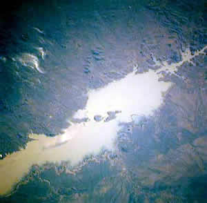
The Cahora Bassa Dam is situated in this province. The Cahora Bassa lake is Africa's fourth-largest artificial lake, situated in the Tete Province in Mozambique. The name Cabora Bassa is an earlier misspelling of the name. In Africa, only Lake Volta in Ghana, Lake Kariba, on the Zambezi upstream of Cahora Bassa, and Egypt's Lake Nasser are bigger in terms of surface water.
In 1859 Richard Thornton completed the first studies of coal occurrence in the Tete Province as part of an exhibition under Dr. David Livingstone
In his report from the trip, Mr. Thornton stated that the coal, which was dug by natives from an outcropping seam on the bank of the River Muntizi, showed no tendency to cake; was free-burning; contained very little sulphur or iron although a large proportion of ash along with a small amount of gaseous matter
Moatize Coal Mine, Tete Province
|
LAKE CAHORA BASSA
 |
The Tete Province is reported to host coal reserves of approximately 6.7 billion tons, of which 3 billion tons represent sub-economic or economic grades Now, the province is regarded geologically as the largest undiscovered coal province in the world and it is estimated that the Province could be producing 25% of the world's coking coal by 2025
The largest coal reserve presently discovered in the Tete Province is the Moatize metallurgical and thermal coal deposit which contains 2.4 billion tons of coal and is located with the Moatize sub-basin
Vale SA bid US$122.8 million for exploration and development rights of the project in 2008
Today, the project is a working mine which has now doubled it's original output and is producing 22 million metric tons of coal per year
ZAMBEZIA PROVINCE
en.wikipedia.org/wiki/Zambezia_Province
Zambezia is bounded on the north by the provinces of Nampula and Niassa, to the east by the Mozambique Channel to the south by the province Sofala and west by the province of Tete and Malawi.
Zambezia is the most-populous province of Mozambique, located in the central coastal region south-west of Nampula Province and north-east of Sofala Province. It has a population of 3,794,509 (2006).
The provincial capital is Quelimane on the Bons Sinais River. Zambezia has a total area of 103,127 km2, much of it drained by the Zambezi River. Much of the coast consists of mangrove swamps, and there is considerable forest inland. Agricultural products include rice, maize, cassava, cashews, sugarcane, coconuts, citrus, cotton, and tea; the country's largest tea estates are at Gurúè.
Fishing is especially productive of shrimp, and gemstones are mined at several sites.
Vasco da Gama landed at the site of Quelimane in 1498. Shortly after, the Portuguese established a permanent presence, and many moved up the Zambezi into the interior, for many years the farthest inland European presence (although over time there was much intermarrying, and few residents were of purely Portuguese descent). |
|